
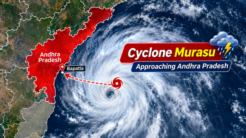
New Delhi: Cyclone Murasu is expected to intensify into a severe cyclonic storm by Monday morning before reaching the south Andhra Pradesh coast between late November 2 and the early hours of November 3. The India Meteorological Department (IMD) has warned of heavy rainfall, strong winds and possible damage across several coastal districts.
According to the weather department, the cyclone moved west-northwestwards at a speed of 27 kmph during the six hours leading up to 2:30 pm on Sunday. At that time, the system was located approximately 480 km east-southeast of Chennai and 550 km east-southeast of Nellore.
Authorities in Andhra Pradesh have started preparations to deal with the possible impact of the approaching storm.
Cyclone Murasu Landfall: Timing and Wind Speed Forecast
The IMD expects Cyclone Murasu to cross the south Andhra Pradesh coastline between Nellore and Narsapur. The likely landfall window is from around 11:30 pm on November 2 to 4 am on November 3.
Wind speeds during the landfall could reach 100–110 kmph, with gusts potentially touching 120 kmph.
Andhra Pradesh Chief Minister N Chandrababu Naidu was briefed by officials about the cyclone’s expected movement. According to the assessment shared with him, the storm could make landfall near Bapatla on the morning of November 3.
Naidu directed government departments to remain prepared for emergency response and rescue operations.
In an official press release, the Chief Minister said that authorities must ensure adequate arrangements for relief and rescue work ahead of the severe cyclonic storm expected near Bapatla.
Heavy Rainfall Alert Across Coastal Andhra Pradesh
Several southern and central coastal districts of Andhra Pradesh are likely to experience moderate to heavy rainfall on November 2, with extremely heavy showers possible in isolated locations.
The weather department has also forecast heavy to very heavy rainfall in several areas on November 3 and 4.
According to preliminary forecasts, extremely heavy rainfall could affect 20 mandals. These include nine mandals in Eluru, five each in Krishna and NTR districts, and one in Bapatla.
The district-wise rainfall estimates for November 3 indicate:
- Eluru: 179 mm
- Krishna: 163 mm
- NTR: 161 mm
The Budameru river system could also receive inflows of approximately 32,500 cusecs.
Apart from rainfall, strong winds may cause significant damage to electricity infrastructure. Preliminary assessments suggest that around 15,128 electricity poles across 12 districts could be affected.
Andhra Pradesh Government Steps Up Rescue and Evacuation Preparations
Chief Minister N Chandrababu Naidu has instructed officials to deploy rescue personnel and emergency equipment in areas considered vulnerable to the cyclone.
He has also directed departments to prepare schedules for restoring electricity supplies in areas where power infrastructure may be damaged. Authorities have been asked to issue cyclone-related weather bulletins every four hours.
The Chief Minister further stressed the need to coordinate with telecom operators to minimise the possibility of mobile network disruptions during the storm.
Naidu also cancelled his scheduled visit to Delhi on Monday to focus on the state’s cyclone preparedness.
The latest warning comes shortly after Andhra Pradesh experienced the impact of Cyclone Arnab, which crossed the coast on October 28 and reportedly claimed seven lives.
Odisha Also Issues High Alert as Cyclone Approaches
The approaching weather system has also prompted Odisha authorities to strengthen their preparations, particularly in the southern parts of the state.
Disaster Management Minister Suresh Pujari said a high alert had been issued, and officials had been instructed to evacuate people from vulnerable low-lying locations and hilly areas.
Bhubaneswar Meteorological Centre Director Manorama Mohanty said rainfall activity was expected to begin on November 2 and become more intense on November 3 and 4.
Authorities in both states are monitoring the cyclone’s movement and preparing for possible emergencies as the system approaches the eastern coastline.
Disclaimer: This article is based on the weather forecasts and official statements included in the source material. Cyclone tracks, wind speeds, rainfall predictions and landfall timings may change depending on atmospheric conditions. Readers are advised to follow the latest IMD bulletins and instructions issued by local authorities. In case of an official evacuation advisory, residents should follow the directions of disaster management officials.